

A significant portion of New York City is established atop loose geological materials rather than solid bedrock. Beneath sections of Lower Manhattan, Brooklyn, and Queens lie layers of sand, silt, ancient lake clay, and man-made fill used to extend the shoreline. Supporting these surfaces are approximately 1,084,954 buildings.
In 2023, geophysicist Tom Parsons from the US Geological Survey led a project to quantify how the mass of these structures impacts the ground below. The total weight of the buildings and their contents was estimated at around 1.68 trillion pounds (about 762 billion kilograms), excluding infrastructure like roads and bridges.
When incorporated into a geological model of the city's subsurface across all five boroughs, the load revealed a notable finding: structures situated on the softest soils have the potential to compact the earth beneath them by up to 600 millimeters (about two feet).

Soft Ground Elevates Subsidence Risks
The findings, published in Earth’s Future by Parsons and his University of Rhode Island collaborators, created a detailed map showing how NYC’s weight interacts with its underlying geology.
According to the USGS summary, predicted ground settlement varies from zero up to 600 millimeters depending on soil and rock attributes and foundation types. For example, skyscrapers anchored deeply into bedrock, as commonly seen in Midtown Manhattan, are expected to cause negligible ground compression.

In contrast, clay-laden soils and artificial fill respond differently, exhibiting predicted compressions ranging from 75 to 600 millimeters with a median near 294 millimeters, roughly the length of a standard ruler.
These numbers represent the total expected ground deformation from building loads under various ground condition assumptions; they are not annual subsidence rates or projections of future ground sinking.
Satellite Data Links Subsidence to Ice Age Aftereffects
The team validated their model results by comparing them with satellite radar and GPS data tracking ground elevation. The city is currently sinking at a rate between 1 and 2 millimeters (0.04 to 0.08 inches) per year in a process known as subsidence. Researchers attribute this gradual sinking largely to residual movements from the last ice age, although some areas are subsiding faster.
Later in 2023, NASA’s Jet Propulsion Laboratory and Rutgers University provided a more detailed map of this ice age legacy in Science Advances. Approximately 24,000 years ago, a massive ice sheet covered New England, exerting heavy pressure on the land, including what is now Albany, and simultaneously causing surrounding regions like NYC to uplift.

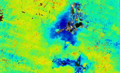
Following ice melt, Earth's mantle began a slow recovery, with elevated areas subsiding gradually. Using ESA’s Sentinel-1 satellite radar data from 2016 to 2023, NASA's team measured the metropolitan area’s average sinking rate at about 1.6 millimeters per year, likening it to the speed at which a toenail grows monthly.
Fastest Sinking Areas Located on Artificial Fill
The satellite observations corroborate the model’s predictions. Brett Buzzanga, a JPL postdoc and lead author, noted that this high-resolution mapping uncovered previously unnoticed sinking hotspots, primarily on filled land.
One such location is runway 13/31 at LaGuardia Airport in Queens, constructed on landfill, which is descending around 3.7 millimeters annually. Southern Governors Island, formed from excavated subway material, is also subsiding rapidly, alongside filled areas such as Coney Island, Arverne by the Sea, and Rikers Island.

Some areas, however, are experiencing uplift rather than sinking. East Williamsburg in Brooklyn shows an elevation gain of about 1.6 millimeters per year, while Woodside, Queens, saw a rise of approximately 6.9 millimeters annually between 2016 and 2019 before leveling off. Co-author Robert Kopp from Rutgers suggested that groundwater extraction and injection wells aimed at remediating contaminated water might influence these patterns, though further research is necessary.
Parsons and his team warned that new tall buildings on soft, waterfront soils may exacerbate flood risks in the future, prompting a need for adaptive urban planning in coastal cities. Past events like Superstorm Sandy in 2012 and Hurricane Ida’s remnants in 2021 illustrate how quickly flooding can impact the city.
One local structure designed to minimize this issue is Arthur Ashe Stadium, the venue for the US Open. It sinks roughly 4.6 millimeters per year—faster than any other hotspot identified by NASA. To reduce its weight and consequential sinking during renovation, the stadium was equipped with a lightweight roof.
- Categories:
- News





0 comments
Sign in to Comment